Miramichi Fishing Report for Thursday, July 25, 2013
I’ll open with several positive statements this week. First, we did get some rain and some cooler temperatures. This resulted in DFO officially opening those pools that had been previously closed. This takes effect Thursday morning (today). (See official notice below.)
There are also quite decent numbers of fish coming through the trap nets beginning this past Sunday, and the fish that had been holding in cold water pools have begun to move up river. There had been some caught early this week in waters that were not closed to angling.
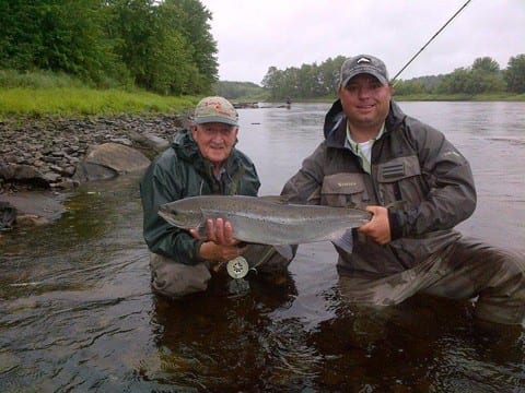
Robert Bell with guide Derek Munn and a nice salmon taken on a shady lady.
Doug White’s Tammerack Sports Fly Shop in Juniper did not have a report this week.
W. W. Doak and Sons in Doaktown said angling was a little better than last week. Water temperature had dropped to the mid 60s Fahrenheit and the level was on the low side of good, but very manageable. Anglers started catching fish on Tuesday as fish began moving again. There were some fresh fish with sea lice.
Flies of choice were Glitter Bears, Undertakers, Butterflies and White-tailed Green Machines on mostly no. 8 hooks.
Derek Munn of Ledges Inn in Doaktown and Mountain Channel in the Rapids area said fishing picked up there the last couple days. The water temperature Wednesday morning was 64 Fahrenheit. They had about a four- inch raise of water Wednesday morning and it was raining hard there Wednesday about suppertime. Tuesday they had seven fishermen on the water and hooked 15 and landed 11. Mountain Channel had very good fishing the last couple of days hooking 12 Tuesday and five Wednesday morning.
Flies of choice were Bombers (Blue & white and brown & orange). Everything else was caught on small black flies and Smurfs.
Herb Barry Sr. of Herb’s Fly Shop on the Station Road in Blackville said fishing had not been good until Tuesday when they started catching fish. Hey had a slight raise in water and the temperature had cooled some.
Flies of choice were Bear Hairs with Red Butts, Bear Hairs with Green Butts, Shady Ladies, Undertakers and Preachers on mostly no. 8 hooks.
Curtis Miramichi River Outfitting in Blackville said some lodges were picking up some fish starting on Sunday. The water temperature had dropped to 68 Fahrenheit on Wednesday morning. and the water had come up slightly. Canoeing conditions were great. They were planning to have a youth fly Fishing School for ages 8-14 if enough people signed up. For more information or sign-ups call (506) 843-2481.
Flies of choice were White-tailed Green Machines, Undertakers and Carter’s Bugs.
George Routledge of George’s Fly Shop at the Mouth of Renous in Quarryville was not available due to sickness. Let us all wish him a speedy recovery!
Jim Laws of Miramichi Hunting and Fishing in Newcastle, Miramichi reported slow angling on the Northwest with only the odd fish being hooked. The good news was that the water had cooled a little and come up some.
Flies of choice were mostly Dry Flies and a variety of Bombers.
Syd Matchett of Trout Brook Fly Shop on the Northwest Miramichi said angling was very slow. They did receive 10 ml of rain Tuesday and had heavy rain late Wednesday afternoon. The water had come up some and the temperatures had cooled off some, so things were improving. Over all there had not been very many anglers out due to the hot water temperatures and low conditions.
Flies of choice were small dark flies such as Undertakers, Bear Hairs and Shady Ladies along with some Bombers, particularly those with orange and green.
Debbie Norton of Upper Oxbow Outdoor Adventures on the Little Southwest Miramichi was also unavailable for comment this week.
So with closures lifted and improving conditions along with fresh fish coming in, it’s time to get out and “on the water”.
Don’t forget to show your support for our sponsors, because without them, this column would not be possible.
Visit Deals 4 U in Miramichi for your grocery needs, and good Cuban cigars to celebrate getting back to the rivers.
Providing quality gear for the outdoor enthusiast all year round, Pronature in Miramichi has you covered. Stop in to check out their rods, reels, tackle and gear.
Fishing Packages are available at the newly renovated Days Inn in Miramichi, located in the heart of downtown Miramichi, just steps from the mighty Miramichi River.
ANY FINANCIAL CONTRIBUTIONS TOWARD HELPING WITH THIS COLUMN ARE GREATLY APPRECIATED. Click here to donate now. A SPECIAL THANKS to all who made contributions.
Thought for the Week: “The contentment which fills the mind of the angler at the close of his day’s sport is one of the chiefest charms in life.” William Cowper Prime
From the MSA
Hi All
I just received the call from DFO saying the pools that had been closed due to warm water and high temperatures will all be open tomorrow morning (THURSDAY). Just a reminder DFO will be issuing a variation order closing 3 pools on August 1st as per the Miramichi management plan – Indiantown Brook, Wilson Brook and Sutherland Brook.
Nola
A notice to recreational anglers will be posted on the DFO Gulf Recreational webpage shortly:
http://www.inter.dfo-mpo.gc.ca/Gulf/FAM/Recreational-Fisheries/Salmon-Angling
GULF REGION CLOSE TIME VARIATION ORDER 2013-059
The Regional Director General, Gulf Region, Department of Fisheries and Oceans, pursuant to paragraph 43(m) of the Fisheries Act and subsection 6(1) of the Fishery (General) Regulations, hereby makes the annexed Order varying the close time for angling, for any species of fish, by certain methods, in certain waters of the Province of New Brunswick.
Dated at Moncton, New Brunswick, on July 24, 2013.
________________________
Jacqueline Richard
Acting Regional Director General
Gulf Region
ORDER VARYING THE CLOSE TIME FOR ANGLING, FOR ANY SPECIES OF FISH BY CERTAIN METHODS, IN CERTAIN WATERS OF THE PROVINCE OF NEW BRUNSWICK
Short Title
1. This Order may be cited as Gulf Region Close time Variation Order 2013-059.
Variation
2. Gulf Region Close time Variation Order 2013-058 is hereby revoked.
Coming into Force
3. This Order shall come into force on the date of signature and remains in force until December 31, 2013
NOTICE
The Regional Director General for the Gulf Region, Department of Fisheries and Oceans, hereby gives notice of the following changes to the seasons for salmon fishing in the waters of the Miramichi Recreational Fishing Area (Salmon Fishing Area 16) for the Province of New Brunswick.
The following salmon fishing pools will be open to fly fishing only, beginning on July 25, 2013:
- The waters of the Cains River, 100 meters downstream of the mouth of Otter Brook to a line drawn from grid reference 20T 288745E 5169162N to grid reference 20T 288721E 5169075N up to 50 meters upstream of the mouth of the said brook to a line drawn from grid reference 20T 289000E 5169261N to grid reference 20T 289068E 5169198N, and including the waters of Otter Brook 50 meters upstream of its mouth, an area locally known as Brophy’s Place (NAD 1983);
- The waters of the Cains River to a point 100 meters off the shore from 50 meters upstream to 100 meters downstream of the mouth of Cold Brook, including the waters of Cold Brook 50 meters upstream of its mouth;
- The waters of the Cains River, 300 meters downstream of the mouth of Salmon Brook to a line drawn from grid reference 20T 292350E 5165039N to grid reference 20T 292465E 5165054N up to 50 meters upstream of the mouth of the said brook to a line drawn from grid reference 20T 292311E 5164868N to grid reference 20T 292424E 5164798N, and the waters of Salmon Brook upstream from its confluence with the Cains River to South Cains River Road at grid reference point 20T 292771E 5164988N (NAD 1983);
- The waters of the Cains River to a point 100 meters off the shore from 50 meters upstream to 100 meters downstream of the mouth of Muzroll Brook, and including the waters of Muzroll Brook 50 meters upstream of its mouth;
- The waters of the Cains River to a point 100 meters off the shore from 50 meters upstream to 100 meters downstream of the mouth of Six Mile Brook, and including the waters of Six Mile Brook 50 meters upstream of its mouth;
- The waters of the Northwest Miramichi River inside a line drawn from a point on land at grid reference 285336E 5202332N located approximately 100 meters upstream from the mouth of Sutherland Brook, then across to the north side of the river at grid reference 285560E 5202535N then downstream from grid reference 285719E 5202415N to grid reference 285505E 5202205N located approximately 100 meters downstream from the mouth of Sutherland Brook and Sutherland Brook upstream to the highway 420 bridge (NAD 1983);
-2-
- The waters of the Northwest Miramichi River to a point 100 meters off the shore from 50 meters upstream to 100 meters downstream of the mouth of Wildcat Brook, and including the waters of Wildcat Brook 50 meters upstream of its mouth;
- The waters of the Northwest Miramichi River to a point 100 meters off the shore from 50 meters upstream to 100 meters downstream of the mouth of Trout Brook, and including the waters of Trout Brook 50 meters upstream of its mouth;
- The waters of the Renous River to a point 100 meters off the shore from 50 meters upstream to 100 meters downstream of the mouth of Butty’s Brook, and upstream from its confluence with the Renous River to South Renous River Road, an area locally known as Duffy’s Brook;
- The waters of the Renous River to a point 100 meters off shore from 50 meters upstream to 100 meters downstream of the pump house located at grid reference 20T 285909E 5187384N (NAD 1983);
- The waters of the Southwest Miramichi River inside a line drawn from a point on land at grid reference 287787E 5189991N located approximately 300 meters downstream from Quarryville Bridge across to the north side of the river at grid reference 287692E 5190123N upstream to grid reference 287239E 5189734N and to grid reference 287361E 5189590N located approximately 300 meters upstream from Quarryville Bridge and Indian Town Brook upstream to highway 108 bridge (NAD 1983);
- The waters of the north side of the Southwest Miramichi River inside a line drawn from a point on land at grid reference 298589E 5196806N located approximately 100 meters downstream from Wilson Brook, southward to grid reference 298667E 5196744N and upstream to grid reference 298518E 5196616N and northward to grid reference 298437E 5196676N located on land approximately 100 meters upstream from Wilson Brook and including the waters of Wilson Brook upstream 100 meters of its mouth, an area locally known as the Bear Den (NAD 1983);
- The waters of the Southwest Miramichi River to a point 100 meters off shore from 50 meters upstream to 100 meters downstream of the mouth Gray Rapids Brook, and the waters of Gray Rapids upstream from its confluence with the Southwest Miramichi River to Route 118, an area locally known as Pete’s Brook;
- The waters of the Southwest Miramichi River to a point 100 meters off the shore from 50 meters upstream to 100 meters downstream of the mouth of Mersereau Brook, and including the waters of Mersereau Brook 50 meters upstream of its mouth;
-3-
- The waters of the Southwest Miramichi River to a point 100 meters off the shore from 50 meters upstream to 100 meters downstream of the mouth of McKenzie Brook, and including the waters of McKenzie Brook 50 meters upstream of its mouth;
- The waters of the Southwest Miramichi River to a point 100 meters off shore from 50 meters upstream to 100 meters downstream of the mouth of Morse Brook, and the waters of Morse Brook upstream from its confluence with the Southwest Miramichi River to Howard Road;
- The waters of the Southwest Miramichi River to a point 200 meters off shore from 50 meters upstream to 100 meters downstream of the mouth of Black Brook, and the waters of Black Brook upstream from its confluence with the Southwest Miramichi River to South Cains River Road;
- The waters of the Southwest Miramichi River to a point 100 meters off shore from 50 meters upstream to 300 meters downstream of the mouth of Donnelly Brook, and the waters of Donnelly Brook upstream from its confluence with the Southwest Miramichi River to the South Road Bridge;
- The waters of the Southwest Miramichi River to a point 200 meters off shore from 50 meters upstream to 300 meters downstream of the mouth of Betts Mills Brook, and the waters of Betts Mills Brook upstream from its confluence with the Southwest Miramichi River to Highway # 8;
- The waters of the Southwest Miramichi River to a point 100 meters off shore from 50 meters upstream to 100 meters downstream of the mouth of Porcupine Brook, and the waters of Porcupine Brook upstream from its confluence with the Southwest Miramichi River to Story Town Road;
- The waters of the Southwest Miramichi River, 100 meters downstream of the mouth of Big Hole Brook to a line drawn from grid reference 19T 716331E 5158713N to grid reference 19T 716324E 5158601N up to 50 meters upstream of the mouth of the said brook to a line drawn from grid reference 19T 716067E 5158724N to grid reference 19T 716116E 5158558N (NAD 1983); and
- The waters of the Southwest Miramichi River, 100 meters downstream of the mouth of Mill Brook to a line drawn from grid reference 19T 728610E 5162685N to grid reference 19T 728621E 5162548N up to 50 meters upstream of the mouth of the said brook to a line drawn from grid reference 19T 728392E 5162687N to grid reference 19T 728380E 5162400N (NAD 1983).
-4-
- Waters of the Little Southwest Miramichi River to a point 100 meters off the shore from 50 meters upstream to 100 meters downstream of the mouth of Parks Brook, and including the waters of Parks Brook 50 meters upstream of its mouth;
- Waters of the Little Southwest Miramichi River to a point 100 meters off the shore from 50 meters upstream to 100 meters downstream of the mouth of Harris Brook, and including the waters of Harris Brook 50 meters upstream of its mouth;
- The waters of the Southwest Miramichi River to a point 100 meters off shore from 50 meters upstream to 100 meters downstream of the mouth of Hudson Brook, and including the waters of Hudson Brook 50 meters upstream of its mouth;
- The waters of the Southwest Miramichi River to a point 100 meters off shore from 50 meters upstream to 200 meters downstream of the mouth of Bartholomew River, and the waters of Bartholomew River upstream from its confluence with the Southwest Miramichi River to Highway # 8 bridge;
Refer to Gulf Region Close time Variation Order 2013-059 issued on July 24, 2013 and for further information contact your local Fishery Officer, or visit the Web site of the Department of Fisheries and Oceans, Gulf Region, under Orders Registry, at the following address: http://www2.glf.dfo-mpo.gc.ca/fam-gpa/cp/ord/index-e.php.
Gulf Region Close time Variation Order 2013-058 is hereby revoked.
Gulf Region Close time Variation Order 2013-059 comes into force on July 24, 2013 and remains in force until December 31, 2013.
Jacqueline Richard
Acting Regional Director General, Gulf Region
E-MAIL:
Doug: I had Elbow Crown Reserve stretch (July 20-22) over the weekend. Water levels were good but water was warm. Fished all pools hard, had one brief hook up on camp pool first evening. Not one fish seen on the entire stretch. Must be holding in a cold water pool down river.
Laurie Grover
Atlantic Salmon Federation News
Thursday, July 18, 2013
River Notes – What’s Hot, and What’s Closed
~~~~~~~~~~~~~~~~~~~~~~~~~~~~~~~~~~~~~~~~~~~~~~~~
River Notes is updated with the latest river conditions, including the known closures in New Brunswick and Newfoundland, counting fence numbers, and fishing reports.
http://atlanticsalmonfederation.org/rivernotes/
ASF Research Blog – This update includes doing ultrasounds on Atlantic salmon.
http://www.asf.ca/research-in-the-field.html
You are invited to the breaching of a Penobscot Dam
~~~~~~~~~~~~~~~~~~~~~~~~~~~~~~~~~~~~~~~~~~~~~~~~
The Veazie Dam will be breached on the morning of Monday, July 22, and you are invited to the event. Full details at:
http://www.asf.ca/you-are-invited-to-veazie-dam-event.html
See an Atlantic Salmon Face-to-Face
~~~~~~~~~~~~~~~~~~~~~~~~~~~~~~~~~~~~~~~~~~~~~~~~
The Atlantic Salmon Interpretive Centre and other locations in Atlantic Canada and Maine provide an opportunity to observe and learn about the king of fish, and to explore the heritage as well. Why not visit a location or two? See a full page of possibilities:
http://www.asf.ca/where-to-see-atlantic-salmon.html
~~~~~~~~~~~~~~~~~~~~~~~~~~~~~~~~~~~~~~~~~~~~~~~~
To keep track of breaking news on wild Atlantic salmon, use the Atlantic Salmon Federation’s presence on Facebook. Log in, search for Atlantic Salmon Federation, and click “like”.
Until next week
TIGHT LINES
DOUG
Giv’er Miramichi is about “What’s up, what’s new, what’s happening”. We are focused on building people up, supporting one another and celebrating our successes.