Striped bass spawning ground angling closure in the Northwest Miramichi River from June 4 to June 8, 2018
Moncton, – Fisheries and Oceans Canada (DFO) announced the dates of the closure of angling during the striped bass spawning period in 2018 in a portion of the Northwest Miramichi River.
From June 4 to June 8, 2018, angling will be prohibited from the bridge in Red Bank downriver approximately 6.5 km, to a line located in front of Williamstown Road and defined by two points as indicated on the following map:
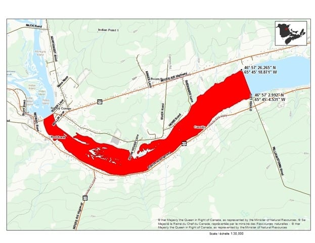 Legend: The map here shows a close-up view of the Northwest Miramichi River in the Red Bank to Cassilis area. The Red Bank-Sunny Corner bridge is visible on the lower left side of the map, and on the right side, the downstream boundary of the angling closure is indicated with a black line drawn between two points located about 6.5 km downriver from the bridge, in front of Williamstown road. The zone that will be closed is marked in red. Coordinates of the two points defining the line are: 46°57’26.265″N/ -65°45’18.871″W (north shore); and 46°57’2.992″N/ -65°45’4.531″W (south shore) (NAD 83)
The Northwest Miramichi River estuary is the only confirmed successful spawning ground for striped bass in the entire Southern Gulf of St. Lawrence (SGSL), as established by DFO science. The closure of all angling in the area and during the time when the striped bass are most concentrated and actively spawning aims at ensuring the best success of spawning activities and the continuous health of the Striped bass stock in the sSGSL. With the exception of the area described above, the recreational fishery will remain open throughout the Miramichi River system during the striped bass spawning period.
The post Striped bass spawning ground angling closure in the Northwest Miramichi River from June 4 to June 8, 2018 appeared first on Miramichi Salmon Association.
Source: Miramichi Salmon Association
Giv’er Miramichi is about “What’s up, what’s new, what’s happening”. We are focused on building people up, supporting one another and celebrating our successes.