Miramichi Fishing Report for Thursday, August 20, 2015
Angling had been decent to quite good last weekend until Sunday when the heat wave struck. Since then, there has been very little angling and even less catching. So this week, I’ll make one general statement that will basically cover the whole system.
[wp_bannerize group=”doug1″]
The water is low and very warm, which has prompted DFO to enact conservation measures to ease the stress on the salmon. On Monday DFO issued a cold-water closure notice for 23 pools, and added to that with an announcement that goes into effect today (Thursday) that basically allows only morning angling on the rest of the river system with the original 23 cold-water pools remaining closed to all angling. These measures will remain in effect until conditions improve enough for the closures to be re-opened. The official notices read as follows:
Please find attached a Notice to Recreational Fishers on angling restrictions to morning fishing only (6:00 am to 11:00 am) in the Miramichi River system (starting at 22:00 hrs on August 19). Angling closure on the 23 salmon holding pools remains in effect. DFO will continue to monitor the water conditions on a daily basis.
Notice to Recreational Anglers
Fisheries and Oceans Canada
Gulf Region
Salmon angling on the Miramichi River
Moncton – August 19, 2015 – Fisheries and Oceans Canada (DFO) wishes to inform the public that angling in the Miramichi River system will be restricted to morning fishing only between 06:00 and 11:00 daily until water conditions improve. This change will be effective as of
Wednesday, August 19, 2015 at 22:00. DFO will monitor these conditions on a daily basis.
This measure applies to the following waters:
- Northwest Miramichi River upstream to its junction with the North and South branches, not including tributaries;
- Little Southwest Miramichi River including the North Pole Stream and the Lower North Branch Little Southwest Miramichi River, not including tributaries;
- Big Sevogle River including the North and South branches, not including tributaries;
- Southwest Miramichi River including the North and South branches, not including tributaries;
- Rocky Brook and Clearwater Brook, not including tributaries;
- Renous River including the North and South branches, not including tributaries;
- Dungarvon River, not including tributaries;
- Bartholomew River, not including tributaries;
- Cains River, not including tributaries.
The angling closure for all species of fish in the following 23 salmon holding pools will remain in effect:
- Confluence of Wildcat Brook and Northwest Miramichi River, including the waters of Wildcat Brook 50 m upstream of its mouth;
- Confluence of Trout Brook and Northwest Miramichi River, including the waters of Trout Brook 50 m upstream of its mouth;
- Confluence of Harris Brook and the Little Southwest Miramichi River, including the waters of Harris Brook 50 m upstream of its mouth;
- Confluence of Parks Brook and the Little Southwest Miramichi River, including the waters of Parks Brook 50 m upstream of its mouth;
- Confluence of Gray Rapids Brook and Southwest Miramichi River, including the waters of Gray Rapids upstream from its confluence with the Southwest Miramichi River to Route 118, an area locally known as Pete’s Brook;
- Confluence of Hudson Brook and the Southwest Miramichi River, including the waters of Hudson Brook 50 m upstream of its mouth;
- Confluence of the Bartholomew River and the Southwest Miramichi River, including the waters of the Bartholomew River upstream from its confluence with the Southwest Miramichi River to the Highway # 8 Bridge;
- Confluence of Mersereau Brook and Southwest Miramichi River, including the waters of Mersereau Brook 50 m upstream of its mouth;
- Confluence of Morse Brook and Southwest Miramichi River, including the waters of Morse Brook upstream from its confluence with the Southwest Miramichi River to Howard Road;
- Confluence of McKenzie Brook and Southwest Miramichi River, including the waters of McKenzie Brook 50 m upstream of its mouth;
- Confluence of Black Brook and Southwest Miramichi River, including the waters of Black Brook upstream from its confluence with the Southwest Miramichi River to South Cains River Road;
- Confluence of Donnelly Brook and Southwest Miramichi River, including the waters of Donnelly Brook upstream from its confluence with the Southwest Miramichi River to the South Road Bridge;
- Confluence of Mill Brook and Southwest Miramichi River, including the waters of Mill Brook 50 m upstream of its mouth.
- Confluence of Big Hole Brook and Southwest Miramichi River, including the waters of Big Hole Brook 50 m upstream of its mouth;
- Confluence of Betts Mills Brook and Southwest Miramichi River, including the waters of Betts Mills Brook upstream from its confluence with the Southwest Miramichi River to Highway # 8;
- Confluence of Porcupine Brook and Southwest Miramichi River, including the waters of Porcupine Brook upstream from its confluence with the Southwest Miramichi River to Story Town Road;
- Waters of the Renous River surrounding the pump house located at N 46.86483,W 65.67698 (WGS 84);
- Confluence of Butty’s Brook and Renous River, and the waters of Butty’s Brook from its confluence with the Renous River to South Renous Road, an area locally known as Duffy’s Brook;
- Confluence of Otter Brook and Cains River, including the waters of Otter Brook 50 m upstream of its mouth. An area locally known as Brophy’s Place;
- Confluence of Cold Brook and Cains River, including the waters of Cold Brook 50 m upstream of its mouth;
- Confluence of Salmon Brook and Cains River, including the waters of Salmon Brook upstream from its confluence with the Cains River to South Cains River Road;
- Confluence of Muzeroll Brook and Cains River, including the waters of Muzeroll Brook 50 m upstream of its mouth;
- Confluence of Six Mile Brook and Cains River, including the waters of Six Mile Brook 50 m upstream of its mouth;
Please note that the following salmon harvesting pools will remain closed until December 31,
2015:
- Confluence of Sutherland Brook and Northwest Miramichi River, including the waters
of Sutherland Brook upstream to the Highway 420; - Waters of the Southwest Miramichi River in Quarryville, 300 m upstream and 300 m downstream of the Quarryville Bridge, including Indian Town Brook from its confluence with the Southwest Miramichi River, upstream to Highway 108 bridge;
- Confluence of Wilson Brook and Southwest Miramichi River, including the waters of Wilson Brook 100 m upstream of its mouth, an area locally known as the Bear Den;
Please refer to Gulf Variation Order 2015-066 for further details. The Orders Registry is available online at:
Orders Registry – Order summaries for existing fisheries
To report any suspicious fishing activity, please contact the nearest Conservation and Protection detachment in the Gulf Region or call Crime Stoppers at 1-800-222-8477.
For more information on this fishery, please contact:
Pierre Bélanger, Senior Advisor, Recreational Fisheries – Fisheries and Oceans Canada at (506) 851-2002
So, until conditions change and the official variation orders in effect are dropped. there will be only morning angling on the waters that are open.
Don’t forget to show your support for our sponsors, because without them, this column would not be possible.
Check out Deals 4 U in Miramichi for your grocery needs, and good Cuban cigars to celebrate getting back to the rivers. Drop by Mac’s Seafood Market to get fresh-cooked lobster and all your seafood needs!
[wp_bannerize group=”doug7″]
ANY FINANCIAL CONTRIBUTIONS TOWARD HELPING WITH THIS COLUMN ARE GREATLY APPRECIATED. Click here to donate now. A SPECIAL THANKS to all who made contributions last season.
If you would like to sponsor this column, give us a call at (506) 352-7668 or email .
Thought for the Week: “I only fish on days that end in “Y”– anonymous
E-MAIL:
Hi Doug! My name is Tyler Storey. I work for the MSA. I would like to ask you a favour! My best friend who is a avid fisherman lost his 13 year old son last week! Gabriel was a great little fisherman who loved this Miramichi River! He died at cadet camp due to an asthma attack. Our River will never be the same without him! Driving up from St. John on fishing mornings, Gabriel loved to read your report as it would always excite him over his trip!
Attached are 2 photos of Gabriel.
Tyler
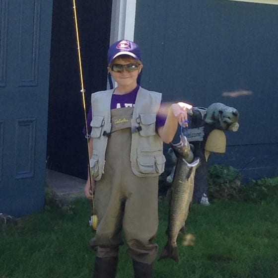
Gabriel
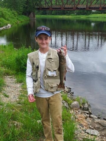
Gabriel
~~~~~~~~~~~~~~~~~~~~~~~~~~~~~~~~~~~~~~~~~~~~~~~~
I hope you enjoy this one. It brought back many great memories: http://theriverscourse.blogspot.com/2015/08/atlantic-salmon-flies-and-gifts-they.html
Very best!
Gary Tanner
~~~~~~~~~~~~~~~~~~~~~~~~~~~~~~~~~~~~~~~~~~~~~~~~
Atlantic Salmon Federation News – Friday, Aug. 14, 2015
ASF RIVERNOTES Reaches 100th Blog Post – With Hopeful News
~~~~~~~~~~~~~~~~~~~~~~~~~~~~~~~~~~~~~~~~~~~~~~~~
Grilse, the salmon that spent one winter at sea, appear to be arriving back in our rivers in good health and improved numbers. ASF Rivernotes is bringing you the river reports in near-real time. Check it out.
http://atlanticsalmonfederation.org/rivernotes/
ASF Scientist Steve Sutton Will Further Atlantic Salmon Outreach and Engagement
~~~~~~~~~~~~~~~~~~~~~~~~~~~~~~~~~~~~~~~~~~~~~~~~
Dr. Steve Sutton, originally from Newfoundland, is focused not only on salmon, but on the human side of encouraging conservation and restoration efforts. Read more.
http://asf.ca/asf-scientist-will-further-atlantic-salmon-conservation.html
Kickstarter Page for LOST AT SEA! Project
~~~~~~~~~~~~~~~~~~~~~~~~~~~~~~~~~~~~~~~~~~~~~~~~
We are spreading the word that the Lost at Sea! Project is seeking support to complete the project. For more on the project, and a link to the page, go to:
http://asf.ca/kickstarter-page-for-lost-at-sea-project.html
Margaree Salmon Museum Turns 50
~~~~~~~~~~~~~~~~~~~~~~~~~~~~~~~~~~~~~~~~~~~~~~~~
Listen to a very special radio interview with Frances Hart on the Margaree Salmon Museum and some of its more interesting visitors.
http://asf.ca/margaree-salmon-museum-celebrates-50-years.html
~~~~~~~~~~~~~~~~~~~~~~~~~~~~~~~~~~~~~~~~~~~~~~~~
DFO does post trap and barrier numbers the middle and end of each month – these can be found at http://www.inter.dfo-mpo.gc.ca/Gulf/asir/count?period=0615&group=1
| Cumulative counts to date of Salmon as of August 15 (* indicates fewer than 5 years are available to calculate the mean, N/A indicates that no values exist for that year, date of operation may vary from year to year.) |
|||||||||||
| Site | Average 1992-1996 |
Average 1997-2001 |
Average 2002-2006 |
Average 2007-2011 |
2012 | 2013 | 2014 | 2015 | |||
| Restigouche River | |||||||||||
| 1 – Upsalquitch Protection Barrier Bar Graph and Tabular Report | 400 | 264 | 237 | 332 | 243 | 302 | N/A | N/A | |||
| 2 – Little Main Counting Fence Bar Graph and Tabular Report | * | 23 | * | * | N/A | N/A | N/A | N/A | |||
| Jacquet River | |||||||||||
| 3 – Jacquet River Protection Barrier Bar Graph and Tabular Report | * | 17 | 24 | 81 | 45 | 107 | 27 | N/A | |||
| Nepisiguit River | |||||||||||
| 4 – Nepisiguit Counting Fence Bar Graph and Tabular Report | * | 31 | * | 133 | 35 | 43 | 10 | N/A | |||
| Miramichi River | |||||||||||
| 5 – Northwest Protection Barrier Bar Graph and Tabular Report | 142 | 152 | 140 | 158 | 120 | 196 | 58 | 64 | |||
| 6 – Northwest Cassilis Trapnet Bar Graph and Tabular Report | * | * | 142 | 258 | 166 | 155 | 41 | 284 | |||
| 7 – Southwest Millerton Trapnet Bar Graph and Tabular Report | * | 245 | 441 | 513 | 446 | 298 | 185 | 421 | |||
| 8 – Dungarvon Protection Barrier Bar Graph and Tabular Report | 136 | 94 | 112 | 142 | 106 | 220 | 54 | 144 | |||
| 9 – Southwest Juniper Barrier Bar Graph and Tabular Report | 111 | 163 | * | * | 194 | 219 | N/A | N/A | |||
| Saint John River | |||||||||||
| 10 – Mactaquac Dam Bar Graph and Tabular Report | 2258 | 1032 | 427 | 351 | 96 | 79 | 66 | 86 | |||
| 11 – Fishway Tinker Dam Bar Graph and Tabular Report | * | 0 | * | * | 1 | 0 | 1 | 0 | |||
| 12 – Nashwaak River Counting Fence Bar Graph and Tabular Report | * | 68 | 47 | 118 | 32 | 30 | 14 | 36 | |||
| Magaguadavic River | |||||||||||
| 13 – St. George Fishway Bar Graph and Tabular Report | 47 | 3 | * | * | 1 | 1 | 1 | 2 | |||
| St. Croix River | |||||||||||
| 14 – Milltown Fishway Bar Graph and Tabular Report | * | 6 | * | * | N/A | N/A | N/A | N/A | |||
| Sackville River | |||||||||||
| 15 – Sackville River Counting Fence Bar Graph and Tabular Report | * | * | 4 | 12 | 3 | 3 | 3 | 2 | |||
| LaHave River | |||||||||||
| 16 – Morgan Falls Fishway Bar Graph and Tabular Report | 173 | 110 | 109 | 59 | 27 | 103 | 21 | 17 | |||
| Cumulative counts to date of Grilse as of August 15 (* indicates fewer than 5 years are available to calculate the mean, N/A indicates that no values exist for that year, date of operation may vary from year to year.) |
|||||||||||
| Site | Average 1992-1996 |
Average 1997-2001 |
Average 2002-2006 |
Average 2007-2011 |
2012 | 2013 | 2014 | 2015 | |||
| Restigouche River | |||||||||||
| 1 – Upsalquitch Protection Barrier Bar Graph and Tabular Report | 744 | 576 | 499 | 520 | 201 | 265 | N/A | N/A | |||
| 2 – Little Main Counting Fence Bar Graph and Tabular Report | * | 125 | * | * | N/A | N/A | N/A | N/A | |||
| Jacquet River | |||||||||||
| 3 – Jacquet River Protection Barrier Bar Graph and Tabular Report | * | 26 | 39 | 127 | 119 | 111 | 25 | N/A | |||
| Nepisiguit River | |||||||||||
| 4 – Nepisiguit Counting Fence Bar Graph and Tabular Report | * | 18 | * | 161 | 105 | 38 | 32 | N/A | |||
| Miramichi River | |||||||||||
| 5 – Northwest Protection Barrier Bar Graph and Tabular Report | 517 | 419 | 414 | 478 | 124 | 140 | 128 | 180 | |||
| 6 – Northwest Cassilis Trapnet Bar Graph and Tabular Report | * | * | 734 | 918 | 237 | 364 | 61 | 1257 | |||
| 7 – Southwest Millerton Trapnet Bar Graph and Tabular Report | * | 718 | 1787 | 1396 | 437 | 407 | 283 | 1139 | |||
| 8 – Dungarvon Protection Barrier Bar Graph and Tabular Report | 402 | 276 | 255 | 362 | 128 | 188 | 66 | 146 | |||
| 9 – Southwest Juniper Barrier Bar Graph and Tabular Report | 317 | 303 | * | * | 80 | 136 | N/A | N/A | |||
| Saint John River | |||||||||||
| 10 – Mactaquac Dam Bar Graph and Tabular Report | 4118 | 2768 | 1273 | 1200 | 83 | 269 | 126 | 596 | |||
| 11 – Fishway Tinker Dam Bar Graph and Tabular Report | * | 2 | * | * | N/A | 0 | 0 | 3 | |||
| 12 – Nashwaak River Counting Fence Bar Graph and Tabular Report | * | 209 | 239 | 364 | 14 | 52 | 46 | 183 | |||
| Magaguadavic River | |||||||||||
| 13 – St. George Fishway Bar Graph and Tabular Report | 51 | 10 | 7 | 5 | N/A | 2 | 5 | 6 | |||
| St. Croix River | |||||||||||
| 14 – Milltown Fishway Bar Graph and Tabular Report | * | 13 | * | * | N/A | N/A | N/A | N/A | |||
| Sackville River | |||||||||||
| 15 – Sackville River Counting Fence Bar Graph and Tabular Report | * | * | 39 | 70 | 8 | 5 | 7 | 29 | |||
| LaHave River | |||||||||||
| 16 – Morgan Falls Fishway Bar Graph and Tabular Report | 1050 | 368 | 458 | 296 | 18 | 72 | 42 | 150 | |||
Until next week (and pray for rain and cooler temperatures)
TIGHT LINES
DOUG
Giv’er Miramichi is about “What’s up, what’s new, what’s happening”. We are focused on building people up, supporting one another and celebrating our successes.